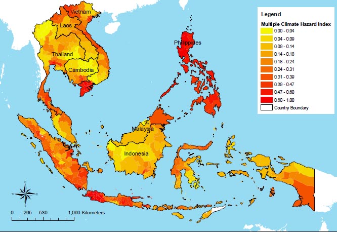
You are here

Vietnam

GDACS Red Alert - Super Typhoon Haiyan (Yolanda) in Laos, Viet Nam, Philippines, Palau


gdacs.org - November 7, 2013


Tropical Cyclone HAIYAN-13 can have a high humanitarian impact based on the Maximum sustained wind speed and the affected population and their vulnerability.

Updated: this report is based on advisory number 20.

  • Tropical Cyclone Hurricane/Typhoon > 150 mph (maximum wind speed of 315 km/h)
  • from 04/11/2013 00:00 UTC to 08/11/2013 00:00 UTC
  • Population affected by Category 1 (120 km/h) wind speeds or higher is 17.7 million
  • Vulnerability: High


(CLICK HERE FOR ADDITIONAL INFORMATION)

CLICK HERE FOR ADDITIONAL INFORMATION FROM THE JOINT TYPHOON WARNING CENTER (JTWC)

CLICK HERE - GDACS Tropical Cyclones - Joint Research Centre

CLICK HERE - Tropical Cyclone Information - Japan Meteorological Agency

Country / Region Tags: 
General Topic Tags: 
Problem, Solution, SitRep, or ?: 

Water - Vietnam facts

By: Sahisna Suwal (Guest Writer)

Located in the Southeastern part of Asia, Vietnam's population totals to over 86 million with an estimated GDP per capita of $3100. Vietnam is the 13th most populous country in the world and almost two-thirds of its people live along the country's three main river basins- Thai Binh, Mekong Delta and Dong Nai.

Fragilecologies: Water Affairs in Vietnam

Exciting things are happening in faraway places. I say that because it is true wherever you live on Planet Earth. What is sparking this statement, however, is my recent trip to Vietnam in order to run a first-ever workshop entitled “Water Affairs”. Perhaps not well-known outside that country, there is a university devoted to the study of various aspects of water, Water Resources University (WRU). It has more than 9,000 students, and it grants degrees from the Bachelor to the PhD level.

As a result of climate change, experts say storms likely to get worse and more erratic.

The Mekong Delta floods each year and small children travel to school by boat. Typhoons and tropical storms blow across the South China Sea to the central coast, often on course from the Philippines. Rains flood the cities and thousands of motorbike exhaust pipes choke on the murky water. But the floods that hit the north-central coast of Vietnam in October 2010 were outside the normal pattern.

(video 1): Living with Floods in Rural Vietnam - Preparing

Part 1 of 2 videos providing an example of disaster preparedness and response that may be experienced in flood prone rural regions of Vietnam.

Country / Region Tags: 
Problem, Solution, SitRep, or ?: 

(video 2): Living with Floods - Community Response

Second video in a two part Disaster Risk Reduction and Response series providing examples to individuals and communities in preparing for and responding to floods and associated risks in rural Vietnam communities.

Country / Region Tags: 
Problem, Solution, SitRep, or ?: 

China and Mekong Dams

China and the Cascading Geopolitics of Lower Mekong Dams

Much has been written on the downstream impact of China’s dams on the Lancang-Mekong River, which flows through or along the borders of five other countries after exiting China.   Most of the discussion relates to the hydrological impact of impounding water in the eight dams along the mainstream Lancang Jiang in Yunnan Province.  Particular concern surrounds the recently completed Xiaowan Dam and the recently approved construction of the Nuozhadu Dam, each of which is of a scale to impound quantities of water that can affect river hydrology throughout the basin.  The Lancang Cascade, as it is termed, has caused considerable controversy in downstream countries, most notably during the 2008 floods and the 2010 drought.  Both the floods and the droughts were blamed by many in Thailand, and some in Laos, Cambodia and Vietnam, on China’s actions.  Recent articles on the downstream implications of altered river hydrology and the need for China to be less disingenuous in its public relations over the issue show the confluence of river hydrology and geopolitics in an international river basin such as the Lancang-Mekong.


EEPSEA Climate Change Vulnerability Map

Climate Map SE Asia

Map date: 2009

Covering 530 sub-national areas of Cambodia, Vietnam, Laos, Thailand, Malaysia, Indonesia and the Philippines, this map combines different elements that contribute to vulnerability - climate-related hazards, capacity to adapt and human and ecological sensitivity - using data from organisations such as the Center for International Earth Science Information Network and the World Wildlife Fund.

All regions of the Philippines are at high risk from tropical cyclones, floods, landslides and droughts, but Jakarta is the most vulnerable city in the region - a victim of the intersection of all climate-related hazards except cyclones.

Other regions regarded as most vulnerable include Vietnam's Mekong River Delta and Bangkok, due to their exposure to sea-level rise.

Full report attached here in pdf.

NOTE: EEPSEA was established in May 1993 to support research and training in environmental and resource
economics. Its objective is to enhance local capacity to undertake the economic analysis of
environmental problems and policies. It uses a networking approach, involving courses, meetings,
technical support, access to literature and opportunities for comparative research. Member countries are
Thailand, Malaysia, Indonesia, the Philippines, Vietnam, Cambodia, Lao PDR, China, and Papua New
Guinea.
EEPSEA is supported by the International Development Research Centre (IDRC); the Swedish
International Development Cooperation Agency (Sida); and the Canadian International Development
Agency (CIDA).

Country / Region Tags: 
General Topic Tags: 
Problem, Solution, SitRep, or ?: 

Pages

Subscribe to Vietnam
howdy folks