User login
Language
Anonymous's groups in this site
User is not a member of any group.
Your groups across all your sites
User is not a member of any group.
Recent Content
Who's online
There are currently 0 users online.
You are here
Dispite the impact of floods upon Vietnam, there are very few up to date flood maps to support disaster risk reduction and management efforts. Technology is available for flood-mapping in Vietnam but little progress has been made due to lack of funding, observes Professor Nguyen Dinh Duong, head of the Institute of Geography's Department of Environmental Information Study and Analysis, Vietnam Academy of Science and Technology (VAST).
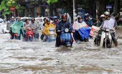
Prof. Duong pointed to the small number of existing flood maps, which had limited reliability and value, noting that no single flood forecasting map had yet been made. The higher frequency and growing intensity of flooding in recent years demanded that a tool be developed to support disaster management efforts, he added.
"It has been a great challenge to persuade local authorities, especially those in places where floods often wreak havoc, to invest in technology in general and to move flood mapping in particular up the priority list. There always seems to be more urgent things."
Flood status maps were easier to create than flood forecast maps because the only input data required for the mapping model were the inundation areas and depths, said the director of the Hydrology and Environment Centre, La Thanh Ha. However, she added lack of topographic maps as a big obstacle in creating maps.
National Remote Sensing Centre director Nguyen Xuan Lam said remote sensing images would be of great help to flood mapping, but Viet Nam lacked its own remote sensing satellites and had to acquire images from other countries.
To meet this need, Vietnam will launch its first remote sensing (RS) satellite in 2014. The satellite, called VNREDSat-1, will be designed and assembled using French technology in 2013, according to Associate Professor Doan Minh Chung, Head of the Space Technology Institute of the Vietnam Academy of Science and Technology.
The 130kg satellite will be capable of capturing earth images from almost 700km into space, to monitor and study the effects of climate change, monitor natural disasters and manage natural resources and the environment.
The VNREDSat-1 project has a total investment of EUR 55.8 million sourced from the French Government’s official development assistance. The project will include the lease of a satellite launching pad and advisors to the project.
The project will be carried out by the academy as part of its strategy on space technology application and research until 2020. Earlier, with the cooperation of US aerospace manufacturer Lockheed Martin, Vietnam successfully launched the VINASAT 1 satellite to provide telecom services.


Recent Comments