You are here

Map date: 2009
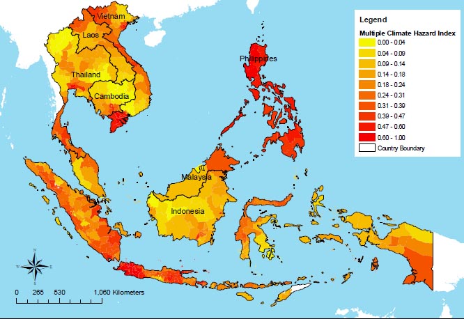
Covering 530 sub-national areas of Cambodia, Vietnam, Laos, Thailand, Malaysia, Indonesia and the Philippines, this map combines different elements that contribute to vulnerability - climate-related hazards, capacity to adapt and human and ecological sensitivity - using data from organisations such as the Center for International Earth Science Information Network and the World Wildlife Fund.
All regions of the Philippines are at high risk from tropical cyclones, floods, landslides and droughts, but Jakarta is the most vulnerable city in the region - a victim of the intersection of all climate-related hazards except cyclones.
Other regions regarded as most vulnerable include Vietnam's Mekong River Delta and Bangkok, due to their exposure to sea-level rise.
Full report attached here in pdf.
NOTE: EEPSEA was established in May 1993 to support research and training in environmental and resource
economics. Its objective is to enhance local capacity to undertake the economic analysis of
environmental problems and policies. It uses a networking approach, involving courses, meetings,
technical support, access to literature and opportunities for comparative research. Member countries are
Thailand, Malaysia, Indonesia, the Philippines, Vietnam, Cambodia, Lao PDR, China, and Papua New
Guinea.
EEPSEA is supported by the International Development Research Centre (IDRC); the Swedish
International Development Cooperation Agency (Sida); and the Canadian International Development
Agency (CIDA).
| Attachment | Size |
|---|---|
| 1.74 MB |

Recent Comments